
Motorcycle Tours
Summary
Here’s one of those “why didn’t I think of that” products.
I can picture the thought process that went into the design of the “Moto Maps”. Someone struggling with paper road maps, trying to stuff them into a tank bag, or writing the directions down on a piece of paper and taping it to the fuel tank. I’ve done it myself, many times.
Moto Maps are the brainchild of Keith Myers, a life-long adventurer and touring enthusiast who also happens to be a motorcyclist. Keith’s a resident of New Hampshire, which is smack dab in the middle of some of the best motorcycle touring roads in the United States.
How do I know? I lived in the Northeast for many years, and I spent huge amounts of butt time in Vermont and the surrounding states. Vermont, by the way, is everything you’ve been led to believe. Cross over into Vermont from any surrounding state and within the first 500 feet, you know you’re in Vermont.
Yep, it’s just like the photos on the calendars!
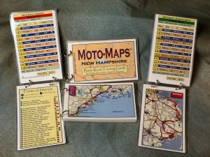
Moto Maps are currently available for Maine, New Hampshire, Vermont and Massachusetts. Each Moto Map consists of a ring-bound selection of plastic-coated cards, measuring 6″ by 3-3/4″. The rings can be popped open to add index cards with more information, limited only by your experiences. The individual pages can also be removed and placed in a tank bag, clear sleeve pocket or even taped to your windscreen.
The first page of the Moto Map has a condensed map of the state, with an outline of several suggested motorcycle tours. Each page of the Moto Map is a zoomed-in version of the road map, showing the major roads and points of interest. Flip the page for a text version of the directions, which can be easily placed underneath a clear tank bag window.
Each tour has been selected by Keith to cover interesting roads, landmarks, cities, towns and other points of interest. The tours range from about 4 to 6 hours; some of them start and end in the same location, while others have different start and end points by design.
Some of the smaller states, like Vermont, have nearly every region covered by the tours. For example, Vermont has 7 tours, covering approximately 1,335 miles. You probably didn’t think there were that many roads in Vermont, eh?
The last page of each Moto Map is a directory of points of interest, historic sites, and other interesting places, like the Ben & Jerry factory (Vermont), the Hancock Shaker Village (an American heritage must-see, in Massachusetts) and the Atlantic Brewing Company in Maine.
More Moto Maps will be available soon, one for Rhode Island and Connecticut and a “New England Sampler”, which will offer one or two rides from each New England state.
The only thing that’s missing is a list of biker-approved restaurants, but I guess it’s up to the rider to choose. The tours cover mostly rural areas, and it’s easy to find a nice, local eatery in just about any little village in the Northeast.
After all, the Moto Maps motto is “We show you the path – You choose the Adventure!”
| Moto Maps for Motorcycle Tours | |
| Available From: MotoMaps | Suggested Retail Price: $9.95 each |
| Product Comments: Easy to use, coated with heavy-duty plastic, fit in pocket or tank bag. Expandable | |
|
wBW Rating: The wBW “Flaming Helmet” Book Review Rating System | Book Reviews Home | More: Motorcycle Tours is a national database of motorcycle roads reviewed by users |
|
Other WebBikeWorld Motorcycle Book Reviews Posts

No Comment