
New BMW Entry-Level GPS Announced
September 10, 2015 (Press release edited by webBikeWorld.com) – BMW announced the new “Navigator Street” GPS today, a (supposedly) inexpensive entry-level navigation system made by Garmin for BMW motorcycles.
It will be available in Europe, USA and Canada with a to-be-determined price.
The new Navigator Street supplements the existing BMW Motorrad Navigator, which will remain part of the product range.
BMW Navigator Street GPS Details
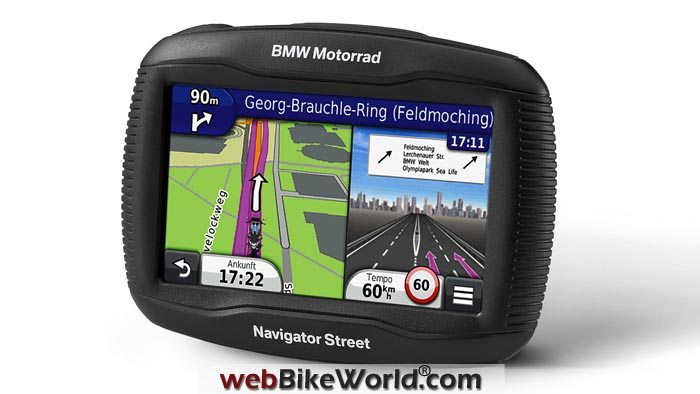
The Navigator Street GPS features a large and bright 4.3″ touchscreen which can be operated reliably with gloves and is also well readable in direct sunlight.
The Bluetooth-capable GPS navigation system can transmit navigation instructions directly to the helmet and allows the rider to make outgoing calls and accept incoming ones while riding using the hands-free function.
BMW said that the rider can call a POI (Point of Interest) directly (only in conjunction with the communication system).
Maps and Free Lifetime Updates
The navigation system is delivered with pre-installed maps of Europe or North America.
Apart from free life-long map updates, the rider can plan his routes individually and comfortably on a PC using the BaseCamp tour planning program available as a free download fromwww.garmin.com/basecamp.
The Navigator Street has a storage capacity of 8 GB. This can be expanded using an additional SD card slot.

Where to Buy BMW Navigator Street GPS
Check Reviews & Prices on Amazon Check Reviews & Prices On RevZillaSee More: Motorcycle GPS, Motorcycle Intercom, Motorcycle Accessories
Route Planning
The Trip Technology implemented in the Navigator Street using Via and Shaping Points for route planning and guidance enables the rider to plan long and detailed motorcycle tours.
Shaping Points are used to set up the route, without being announced as interim destinations during navigation.
Up to 150 Shaping Points between 2 Via Points are possible (these can only be set up in BaseCamp on the PC, not on the navigation device itself). With the “Winding Road” routing option, the Navigator Street calculates the route with the most curves.
Special navigation extras of the BMW Motorrad Navigator Street include the 3D intersection view with lane change assistant as well as the TracBack function.
The 3D intersection view shown in the split-screen provides optimum orientation at complex intersections and junctions and the TracBack function permits returning to the starting point along the same route.
In addition, the SKIP function allows the rider to skip waypoints and the motorway POIs provide information about fuel stations and restaurants for the next exit.
Other Features
The new BMW Motorrad Navigator Street also features an integrated travel computer with compass and speed limit display which warns the rider about the permitted maximum speed on most roads.
Motorcycles tours can be recorded and transmitted free of charge using Garmin Adventures (supported by BaseCamp).
BaseCamp can be used to combine waypoints, photos with geo-tags, YouTube videos and more and transmit them online.
Garmin Adventures also allows users to rate routes, read reviews and download routes created by other riders.
The Mount Cradle supplied with the navigation system can be used to attach the Navigator Street securely to all BMW motorcycles which are not fitted with the optional navigation preparation feature.
It has been designed to fit all known motorcycle-specific mounts by BMW Motorrad (not included).
It features a 12 V connection cable for connecting it to the optional accessory connector for use with the motorcycle’s electrical system to provide power for the Navigator Street.
The BMW Motorrad Navigator Street is equipped with an integrated lithium ion battery. The battery is charged by the electrical system during riding and via mini USB socket from the computer or the optional charging device when off the bike.
The BMW Motorrad Navigator Street is supplied with a mini USB cable, a Mount Cradle including 12 V connection cable, pre-installed maps and free of charge, life-long map updates.
More information will be available as the product is released and we hope to have one for a full review.
Master Listing of All wBW Motorcycle Product Reviews
Where to Buy BMW Navigator Street GPS
Check Reviews & Prices on Amazon Check Reviews & Prices On RevZillaSee More: Motorcycle GPS, Motorcycle Intercom, Motorcycle Accessories
Owner Comments and Feedback
See details on submitting comments.
From “D.T.” (September 2015): “Just wanted to let you know that your comment below is incorrect. Up to 150 Shaping Points between 2 Via Points are possible (these can only be set up in BaseCamp on the PC, not on the navigation device itself).
BaseCamp is not the only application that can be used to create Routes with Shaping Points for the Garmin GPS that use the Garmin Trip Planner software.
Furkot.com, the online Trip Planning Application, can Export Garmin Routes with Shaping Points.”
Editor’s Note: That text came directly from BMW, who may not be aware of the furkot.com app.

No Comment